The Largest Industrial Accident in the City's History, Still Lying Where It Fell
The Schoellkopf Power Station stood at the bottom of the Niagara Gorge on the American shore, a short way downstream of the falls. For most of a century it was one of the reasons Niagara Falls, New York existed as an industrial city at all. On the afternoon of 7 June 1956 the rock wall behind it collapsed and buried it. Nobody rebuilt, nobody cleared it, and the wreckage is still there.
The site began with Jacob Schoellkopf, a Buffalo miller who in 1877 bought an unfinished hydraulic canal and, more importantly, the water rights that came with it. Power was first generated here in 1881, initially just to drive local mills. Over the next forty years the operation grew down the gorge wall and along the river into a chain of stations, completed in 1924, that ranked among the largest hydroelectric plants anywhere in the world.
What killed it was water, but not the river. Water had been seeping through the gorge wall behind the powerhouse for days, and on the afternoon of the collapse the rock was heard cracking. That warning is the reason this is a story about one death rather than dozens, the crew had time to get out. Then the wall came down and took most of the station with it.
A weekday afternoon
Water rights bought 1877
Among the world's largest
No ticket, no booking
Longer if photographing
Once the leaves are down
What You Actually See From the Rim
This is a viewpoint, not a site you enter. You stand on the gorge rim and look down at a terrace of concrete and stone wedged between the cliff and the river. Knowing what you are looking at is most of the experience, which is why the photographs below are worth studying before you go.
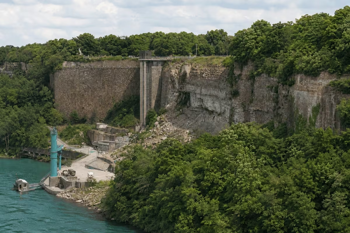
The dominant feature is the retaining wall, a long, coursed stone face that held the gorge back behind the powerhouse. It survived. Beside it the rock is raw and grey where the wall of the gorge sheared away, and below that the slope is a jumble of blocks that have never been moved. A tall concrete structure still stands against the cliff. Down at the water there is a working intake and some modern plant, which is the part people mistake for the ruins; the ruins are the older stone above and behind it.
Compare that with the historic photographs and the scale lands. The powerhouse ran the whole length of the river frontage, four storeys of arched windows, with a second tier of buildings on the rim above. Almost none of the building is left. The wall it stood against is nearly untouched.
Access, Cost & Visitor Information
| Monday | 7:00 AM – 11:00 PM |
| Tuesday | 7:00 AM – 11:00 PM |
| Wednesday | 7:00 AM – 11:00 PM |
| Thursday | 7:00 AM – 11:00 PM |
| Friday | 7:00 AM – 11:00 PM |
| Saturday | 7:00 AM – 11:00 PM |
| Sunday | 7:00 AM – 11:00 PM |
These are Niagara Falls State Park's grounds hours, the overlook has none of its own, and there is no gate. In practice daylight is the real limit: there is no lighting in the gorge and nothing to see after dark.
Do not try to reach the wreckage
The gorge floor around the ruins is closed to the public, and the slope above it is the same rock that failed in 1956. The gorge here has a real record of rockfall. Every legitimate view of this site is from the rim, looking down, and the rim is where the photographs on this page were taken from.
The Station Before, and the Gorge After
Three photographs: the gorge as it is now, the station intact from across the river, and the same stretch from downriver with the city on the skyline. The point is the comparison, line the stone retaining wall in the modern picture up against the same wall in the historic ones and you can see exactly how much of the site is still standing, and exactly what is missing. Click any of them to enlarge.


Six Things Worth Knowing
Schoellkopf Ruins: Frequently Asked Questions
Can you walk down to the Schoellkopf ruins?
No. The wreckage sits at the bottom of the gorge on ground that is closed to the public, and the slope above it is the same unstable rock that brought the station down. You look at the ruins from the rim, from above. The Niagara Gorge Trail system runs along the top of the gorge in this stretch and gives you the angle.
What actually happened on 7 June 1956?
Water had been seeping through the gorge wall behind the station for days and the rock was heard cracking that afternoon, which gave the crew time to get out. The wall then gave way and buried most of the station under rock. One worker was killed. It remains the largest industrial accident in the history of Niagara Falls, New York.
Is there anything left to see, or is it just rubble?
There is more than people expect. The long stone retaining wall that held the gorge back is still standing, along with concrete towers, foundations and the flat terrace the powerhouse stood on. In the photographs on this page you can line the modern view up against the station as it was and match the wall almost stone for stone.
Do I need a ticket?
No. The ruins are viewed from public land inside Niagara Falls State Park and cost nothing to look at. Parking inside the park is charged in season, and the Niagara Gorge Discovery Center nearby charges admission, but the view itself is free.
When is the best time of year to see them?
Late autumn through early spring, once the leaves are down. The gorge walls here are heavily wooded and in full summer the canopy hides most of what is below, the summer photograph on this page shows the problem. In November or March you can see the whole terrace.
How long should I allow?
Fifteen to thirty minutes at the overlook is enough unless you are photographing it. Most people fold it into a walk along the gorge rim or a visit to the Niagara Gorge Discovery Center, which is a few minutes away and tells the geological half of the same story.
Why did the collapse matter beyond the site?
Losing the station took out a very large share of the region's generating capacity overnight, at a time when local industry ran on it. The response was the Niagara Power Project: Congress authorised a replacement, and the Robert Moses plant opened downstream at Lewiston in 1961, which is where the American side's power has come from ever since.
Is it worth a special trip?
Honestly, not on its own. It is a ten-minute stop with a very good story attached, best combined with the Discovery Center, the gorge rim walk or Whirlpool State Park. If you are interested in industrial history it is one of the most striking things on the American side; if you are not, it is a view of a wall.
What Visitors Consistently Say
This is a free viewpoint rather than a product we sell, so there is no verified booking rating to show and we will not invent one. What follows is a summary of the themes that recur in public reviews and local write-ups, which tells you more than a score would.
Location & Directions
The ruins lie at the base of the Niagara Gorge on the American side, below the rim path inside Niagara Falls State Park, a short way downstream of the American Falls.
Complete Your Niagara Falls State Park Visit
The ruins are a ten-minute stop. These are the places within walking distance that turn it into an afternoon.